Save the Aral Sea
WMO Bulletin, Volume 44 No.1, January 1995
Water resources monitoring system for the Aral Sea
Naginder S. Sehmi and Serge A Pieyns
Introduction
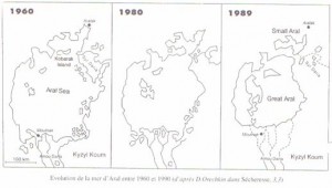
At the time of independence of the central Asian states in 1992, over one third of the Aral Sea had disappeared and it had been effectively divided into two parts (Figure below). This occurrence pricked the conscience of world’s environmentalists and caused great concern amongst politicians and the public generally. This concern even crossed traditional political bounds to the extent that the North Atlantic Treaty Organization (NATO), a western military alliance, decided to sponsor, as part of its “Cooperation Partners” programme with the Newly Independent States an Advanced Research Workshop on Critical Scientific Issues of the Aral Sea Basin. The purposes of the workshop were to define and discuss critical scientific issues related to the Aral Sea Basin (ASB) and to promote scientific collaboration on these issues between scientists from NATO countries and those from “Cooperation Partner” countries. The workshop was held in Tashkent, Uzbekistan from 2 to 4 May 1994.
Previous studies undertaken by UNEP, the World Bank, UNDP, European Union and others on the ASB have usually been of an investigatory/evaluation nature with the aim of redressing water and environmental problems. This workshop was the first of its kind which provided a forum for individual scientists and experts to exchange their points of view on the same problem in an open and free manner.clip_image002_028
Why are water levels falling?
Scientists and in particular climatologists have tended to restrict their search for the causes for the lowering of the water level to the sea itself, often forgetting the rivers that feed it. Change of climate might be a long-term cause: a decrease in precipitation and increase in evaporation in the sea. However, if this were so, it is difficult to explain the unprecedented rise of the adjoining Caspian Sea. Climate change might be a contributory factor especially at the local scale, but the main causes must be sought in the response of the entire basin of the Aral Sea which has become a “man-made lake”. This is because man has diverted river waters to produce food and fibre, and the sea receives what man allows. Therefore, the solution to the problem lies in the study of the production of water in the snows and glaciers of the mountains of the upper catchment of the Syr Darya and Amu Darya, and of the manner in which this water is used and managed, before it flows into the Aral Sea through the rivers and by subsurface flow. In short, only by monitoring and understanding the water balance of the ASB can one judge whether the region can experience sustainable development and the sea can be saved.
The situation is well understood by those who harnessed the water resources of the ASB. There is little doubt that scientists and water experts in these countries also know how to reverse the degradation process. What the countries lack are the means: financial, managerial and possibly high-level expertise. Above all there has to be a strong political will to establish regional cooperation in the field of water management. To mobilize these means and to nurture the political will, at a time when the countries concerned are suffering from the combined effects of the painful process of political and socioeconomic metamorphosis, would be a noble act which should guide the efforts of the international community in order to save the Aral Sea.
Nascent market economies in the ASB countries are highly vulnerable and their needs are closely linked to the development of water resources. Some 98% of the region’s GDP is water dependant. However, demographic growth is outstripping economic and development growth, and the salinity of the irrigated soil and the irrigation water is increasing dramatically, which leads in turn to a need for increased growth of irrigated areas, higher water demand and drainage. Therefore, upgrading the irrigation infrastructure and its information and control system are of vital importance.
The data problem
The Aral Sea and the five republics of Kazakhstan, Kyrgyzstan, Tajikistan, Turkmenistan, and Uzbekistan are inexorably inter-dependant as regards their water resources. To stabilize or to raise its water level, to reverse environmental degradation and alleviate the suffering of the inhabitants depends upon the water management capability of the two international basin authorities of Amu Darya and Syr Darya. Their efforts depend on the continuous on-line availability of hydrological and meteorological data from each country’s National Hydrometeorological Service (NHS). To make a water balance including determination of the sources of pollution implies that not only the past data and the monitoring system must be maintained, but also considerably improved and expanded to meet the new needs of users.
The NHSs, being public services, offer data free of charge. In the current economic situation, such non-revenue-producing but essential services are subject to severe budgetary reductions, to such an extent that the NHSs cannot even maintain the existing monitoring systems. Scientists and water resources managers frequently complain about lack of sufficient hydrological and related data, but they often forget to advocate in concrete terms how this deficiency should be rectified.
At the time of independence, water resources data from the ASB was centralized in Tashkent. The network originally consisted of about 900 hydrological stations, 300 meteorological stations, 400 snow depth measuring points monitored by helicopter surveys, 3 high-altitude research sites.
This network is now divided among the five republics, two of which are essentially water suppliers and three are water consumers. During the short period since independence, the network has decreased dramatically. In the Amu Darya headwaters in Tajikistan the number of meteorological stations has declined from 25 to 10, and that of hydrological stations from 7 to 2. Only sporadic data are received in Tashkent. In the Syr Darya headwaters the meteorological stations have decreased from 20 to 12, and the hydrological stations have remained at 15. Snow measuring by helicopter has ceased and about 30 snow measuring routes have been closed. Furthermore, measuring devices are old, and the stock of spare parts has been exhausted. The overall impression is one of rapid decay. If unchecked, this situation will lead to grave inefficiencies in socioeconomic activities.
Solutions
It is essential to keep the monitoring system united so as to optimize the supply of water for agricultural production and other uses, and to permit an equitable sharing of water and harmonious development of the quality-of-life. Recognizing the problem, the five NHSs have expressed their political will by signing an agreement to exchange data.
As a first step, the World Bank in cooperation with WMO has proposed to provide support to meet the current needs by arresting the decline in data quality and quantity required for the day-to-day water resources management. This can be done quickly because the institutions are efficient and the quality of the professional staff is high. What is urgently needed is to re-equip the data collection network, especially in the mountainous areas ( up to 80% of the river flow is from snow and glaciers) with a system of satellite based data collection platforms (DCPs) and data loggers, and to upgrade the computer capacity for data base development and analyses.
The second step is proposed to concentrate on the overall strengthening of the NHSs in an integrated fashion, and to develop a long-term programme for developing a monitoring system to serve the ASB as regards surface water, groundwater and related meteorological elements. Such a system could form the Hydrological Cycle Observing System of Central Asia ( HYCOS – Central Asia), conforming to the international standards and regulations agreed upon by the Members of WMO. Ultimately, HYCOS – Central Asia should consist of at least 200 automatic DCPs.
Conclusion
Continued debilitation of the NHSs will erode their capacity to assess and monitor the water balance of the ASB. For developing an integrated modern water resources monitoring system it is essential that the friends who wish to “save the Aral Sea”, be they researchers, environmentalists, climatologists or water resource managers, clearly indicate their requirements for data and support efforts to re-build the capacity of NHSs to supply these requirements.
_____________